
A guide to getting turn-by-turn (TBT) navigation working on the Edge 1000
Intro
I frequently cycle up to and over 100 miles, often in places I’ve never been before, pre-planning my route to visit particular places, follow the nicest roads/avoid the nasty roads and pass the features I want (cake stops!) when I want. Rather than keep stopping and looking at a map/route-card, I’ve used a Garmin Edge to follow my desired route for many years with great success.
Though the Edge 1000 is pretty good out-of-the-box, people do struggle with the navigation side of things, so this page details how I have it set up and how I use it for navigating.
This guide is broken down into just 5 steps:
- Set up your Edge 1000 – some of the default settings are a bit odd so we’ll change them (only needs doing once)
- Plan your route
- Download your route
- Copy your route onto the Edge 1000
- Go ride!
After the guide there’s some sections covering other relevant information.
Maps
A quick word on maps as they are a fundamental part of turn-by-turn navigation, because that’s where the Edge gets the turn-by-turn information from, not from the route file.
Really important that you understand the following: If you don’t have a map covering the area you’re riding in, you won’t get turn-by-turn information. If the map omits/includes features you do/don’t expect, then you won’t get the results you expect.
The Edge 1000 comes with a pre-loaded map which is based on the Open Street Map (OSM) project. You will get updates to this map via Garmin Express.
So far I’ve had no issue with the included maps though it’s possible to use the old style Garmin City Navigator and OS maps on SD card if you prefer.
You can also use a different “cut” of the OSM maps that you download yourself (see here for a guide on how to get them) should you need an area not covered by the included map, you have issues with it or would rather a map that didn’t include cyclepaths (in which case select Generic Routable as the map type).
Initial setup
Some of the default settings on the Edge 1000 are a bit odd/undesirable/wrong so I always make a few changes (this only ever needs doing once).
Select Tools from the main menu, Activity Profiles, a particular activity, Navigation, Map and set the options like so:
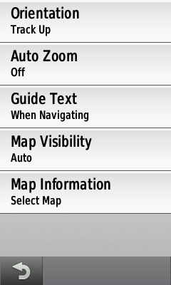
When done, press the back arrow, select Routing and set the options like so:

When you get to Avoidance Setup, set the options like so (or as applicable to your bike type):

Keep pressing (or press and hold) the back arrow to get out of the menu system.
Obviously this needs repeating for each profile you’ll be using turn-by-turn navigation with.
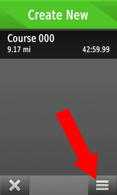
Select Courses from the main menu, then press the three-line icon in the bottom right (note you will need at least one course loaded before this button is enabled) and ensure both Turn Guidance and Off-Course Warnings are enabled.

Plan your route
There are numerous websites out there that allow you to pre-plan a cycle route but for me, RideWithGPS is by far the best so that’s what I’ll assume you’ll be using.
Some tips for route planning (originally written by Uncycle on the Garmin forums):
- To avoid the confusing the Edge 1000, always finish a circular route 10-15 metres away from the start
- When plotting a route always click in road segments NOT at junctions (to avoid little side stubs when you click a bit inaccurately)
- Allow the website’s routing algorithm time after each click to complete its routing to that point (avoids odd little loopbacks)
- Go round the course at max zoom to check that all is correct
Another little trick that I do is to grab “peg man” and hover him over the route, if my route lights up blue, it means the Google StreetView car went down that part of the road and so there shouldn’t be a problem going down it myself. If part of my route doesn’t light up blue then I need to ask why did the StreetView car not go down there? Most likely it’s an unpaved or private road that Google thinks is navigable when in fact it’s not practical and/or legal to do so.
On RideWithGPS you have a choice of maps, selectable from the drop-down in the top right of the menu. If you use one of the OSM or RWGPS ones you will be using the same mapping data as used on the Edge 1000 (subject to version differences) and should therefore get excellent consistency with the turn-by-turn navigation/routing (thus avoiding the issue 1 outlined below).
Download your route
Once you’ve planned your route on RideWithGPS, use the Export feature to save the route as a GPX Track.
Copy your route onto the Edge 1000
Plug the Edge 1000 into your computer, wait for it to be recognised and then copy the GPX file you exported into the GarminNewFiles folder on the Edge 1000. I use the GarminNewFiles folder on the SD Card as it means that should the Edge 1000 ever do a “reset” during a ride then at least my route is still safe (I started doing this with one of the very early Garmin Edge series that did occasionally reset; I’ve never experienced it on a recent model but old habits die hard).
Go ride!
Once you’ve done the above, actually navigating a route is really simple, just select Courses from the menu screen, select the desired course & hit the big green Ride button. This will cause the Edge 1000 to:
- Overlay the route on the map page (in purple, you can’t change that)
- Give you turn-by-turn instructions (bleep & on screen prompt)
- Give a bleep and an instruction for every entry in the RideWithGPS cue sheet (if you used the TCX option)
- Show a “Recalculate?” message if you stray off the route
Alternative ways of navigating
The above is how I chose to use the Edge 1000 for navigating, but there are alternatives:
Alternative method #1: On the Course Options screen (as described above), have Turn Guidance disabled and Off-Course Warnings enabled. When you hit the big green Ride button in the course, you will get the purple line to follow and get a bleep/warning if you stray off it, but it’s up to you to be aware of the turns (typically by leaving the Edge on the map page).
Alternative method #2: On the course details screen select Settings, Map Display and set Always Display to On. This will always show the route on the map screen (in the colour you chose) and you just need to follow the line. You don’t ever hit the Ride button and you don’t get turn or “off course” warnings.
Quirks/Issues
There are of course some quirks/issues/bugs:
- If the maps the Edge 1000 is using don’t contain a path that you used when planning your route, it will probably change your route during the “Calculating” phase. This is because turn-by-turn directions are calculated from the on-board maps i.e. the Edge 1000 comes up with a route that matches your GPX as closely as possible using tracks/roads it knows about. So if the Edge map doesn’t have a track that your GPX file goes down, then it will reroute you around it. I’m not sure I like that, but Garmin had to make a choice on how to deal with that situation and they chose that method (I’d rather they stuck to the original route but didn’t have TBT). The use of the more comprehensive OSM instead of their own maps has all but eliminated the issue for me though.
- Sometimes you don’t get a turn prompt when you expect one. This is because the map the Edge 1000 is using doesn’t know about or understand the junction and isn’t a fault with Garmin. Typically this happens when the map thinks a junction has a different layout (different road priorities) to what is marked on the road.
- When you hit the Ride button, the Edge 1000 will say “Calculating” from 0 to 100% whilst it works out the turn-by-turn notifications for your route. The speed at which it goes through this process is not consistent (e.g. it may take as longer to get from 30% to 40% than it did to get from 20% to 30%). It may stick on 100% for a short while at the end, especially on longer routes.
Don’t forget that the beauty of Garmin using OSM maps is if you suffer from problem 1 or 2 above, you can do something about it by going to OpenStreetMap and making the changes.
Ride WithGPS Premium Users
It’s worth noting that RideWithGPS Premium users have two extra features directly relevant to Garmin Edge users:
- Garmin Write – this sends a route directly to your Garmin Edge 1000 meaning the Putting a route onto the Edge 1000 section is completely redundant and the whole process is easier/quicker.
- If you use the TCX format you can tick the “Notify before turn?” option to get an extra bleep just prior to junctions.
There are lots of other benefits to being a premium user as well as the fact you’re supporting a great website run by two great guys so it’s worth considering.
Any Questions?
If you’ve any questions or comments re navigation using the Garmin Edge 1000 then leave a comment below. Please don’t ask generic questions about the Edge 1000 or questions not related to the above as unfortunately I’ve not got time to answer those, use the Garmin Forums instead.
Many thanks for this info!
Can you explain your choices for maps and navigation settings? I am not sure what Guide Text does or why you would want auto-zoom off for example?
No problem for the info/page Ian, just hoping it’s of use to others (my equivalent page for the Edge 800 has been really popular).
Guide Text sets when the turn-by-turn navigation prompts are shown, and that’s all the manual says! I’ve stuck with “When Navigating” because that’s what I had on the Edge 800. Not sure what the other options do on the Edge 1000, need to experiment to see if anything else might be better.
Auto Zoom is an easy one to answer. I often just glance at the map and if the zoom is consistent then I can do this with a sense of scale. If Auto Zoom is on, I’d need to look at the scale too and that’s not that clear. I’m doing a fairly consistent speed so I know what scale I like. Just personal preference really.
Hope that helps.
Your comment on RWGPS’ “Garmin Write” feature is incorrect. The file written is a “fit” file which is identical to the “TCX” format. This is why the “Garmin Write” feature allows you to change how far in advance you want notifications for the change in direction.
Also, for the “Avoidance” options, it is a well-known fact that bike roads tend to be tagged as highways internally and if you tell the 800/810/1000 to avoid highways, it may not take you onto a cycling path. On my 1000, I disabled all avoidance features.
In Map / Orientation feature, I recommend most people use “Automotive”. This provides the rider a 3D perspective just like in the car and is very easy to read when cycling.
Last, not sure why you have Auto Zoom off. It works quite well. You don’t need to constantly fiddle with the zoom factor as you enter towns or change of direction…
Thanks for the info.
I’ve updated my RWGPS section to remove the GPX Track reference.
I’m not sure on what basis you can say it’s a “well known fact” that contributors to Open Street Maps mark a cycle path as a “Major Highway”. I very much doubt they do that. In the UK at least, Major Highways are dual carriageways and motorways and I don’t want ride my bike on either. That said the avoidance options are of course totally personal and if you’ve got re-calculation switched off the Edge 1000 shouldn’t be taking any of these settings into account anyway.
Your other two points are also personal and people can of course experiment and chose the options that work best for them. Personally I didn’t like the “Automotive” view on the 800 (not tried it on the 1000) and I don’t find the need to change the zoom level unless there’s a problem and I need to see more of the map, at which point the Garmin wouldn’t know that either so I’d still have to do it manually.
This page is just a guide to allow people to get turn-by-turn navigation working quickly and reliably. Hopefully your comment and this response will encourage to experiment a bit once they’ve got the basics working.
@forgot. I suggest you read up on how cycling paths end up getting tagged in the actual GPS map files. The problem is that there is no way to tag something as a cycling path. Therefore, in order to give them priority over roads, many map systems give the cycling path the same priority level as a highway. If you tell the Edge 800/810/1000 to avoid highways, there is a good chance it will not select a cycling path as its primary route. Read this for more info: https://sites.google.com/site/openfietsmap/tips-tricks/basecamp/basecamp-3-3-en
And, yes, the other comments are preferences but they are based on comments of many many GPS users that I deal with. When people use the GPS primarily as a routing tool (like in your car), the Automotive mode is generally easier to use for many.
Interesting read. Though I’m not wanting the Garmin to do any routing so it’s all a moot point anyway 😉 I only include the screen because otherwise people would ask what I have those settings as!
As I said, I’m not dictating what settings people use, I’m just trying to produce a guide that will allow people to get turn-by-turn navigation working for their own routes because the manual doesn’t explain it. I first did this for the Edge 800 which wasn’t straightforward at all, so I wrote a page showing how I did it so people could at least get it working. Though the Edge 1000 is much easier (mostly thanks to the included maps), I think some people will still struggle and hence I’ve done a page for them.
People can tweak things after that if they don’t like the exact way I do it, but at least I’ve given them a good base point to work from especially as in my earlier comments and your comments we’ve explained the alternatives.
I forgot to say… thinking about it, it might be better to set Avoidance to all off as you suggest, just in case it does affect the way the Edge 1000 calculates the TBT for a given route. If you remove the limitations and provide a route, the Edge might be more likely to stick to that route.
I’ve now checked and RWGPS “Garmin Write” feature gives you the choice of writing it as a GPX Track, GPX Route or TCX.
I’ve had a few problems with mine, my fault thou, as I don’t tech on the bike I found following the map a pain until I got home and changed it to 3D. I’m still thinking of selling it and just riding like before.
These are a good tool for training but it’s not for me.
A useful addition for this great start of a reference, is to do the same for the segment functionality on the Edge 1000. As you can read in the garmin forums, we are all learning how to use this, and what the quirks are…..
🙂 Would love to Bobbo, unfortunately I don’t have any real interest in segments. But why not go for it yourself, am sure people will thank you for it.
Just bought an Edge 1000 and the day after I used it for a 167 km ride in almost unfamiliar territory.
It is pretty annoying that it can find the cycleways along the highways and motorways.
I’ve tried to allow it to use highways ect. but no, it will absolutely take me for a longer route than nessary.
When that said, its a pretty nice device that can do all the things I want (except navigating along major routes).
Thanks for a great guidance.
Did you plan the route yourself? If not then that’s the best way as it should follow your idea of the best route.
It’s a cycle computer so it’s not too crazy a concept that it knows about cycleways! But I agree, it’d be better if you could turn them off. If you don’t want them then follow the instructions in the last paragraph of the Maps section above and use them instead of the included maps.
This is excellent. I had the Edge 705 which I loved and when the new 1000 came out, I had to have it. I noticed right away that they had taken out the function of when you bring up a course, click on Go, that it calculates and loads the route, then you can hit the settings under the route and click off that stupid idiotic Virtual Partner, and make sure you have off course warning turned on and turn by turn, turned on. I liked that. They make the 1000 too confusing (especially if you had a past model Edge). Being able to turn the turn by turn off/on was a good function but I read in the forum that people were bitching about it and Garmin took it out.
Thank you really useful blog, saved me hours of research
I’d be interested in your thoughts on planning a route on the Garmin itself? We leisure cycle a lot overseas and don’t have access cheaply to the Internet and we often change our routes as we cycle so we were hoping the garmin might do as our cycle route planner without other kit.
It will do that, and I suspect the better maps on the Edge 1000 will mean it’s okay. If you don’t like the routes it chooses then you can just ignore it and allow it to recalculate.
I appreciate this comment is probably best on the other guide on how to add a map but that comment section is well old now… I am trying to add my Australia map to my Garmin 1000 not 800 and I can’t! I have followed the instructions and it’s not on there. I’ve moved it onto the device from the card and into the custom maps folder still no joy. All guides on net are for the 800 well it doesn’t work!! All help appreciated.
It’s a custom map downloaded following dcrainmakers instructions. It’s the .img file unzipped etc etc..
I’ve only briefly played with alternative maps, purely out of curiosity. I just took the same .IMG file I was using on my Edge 800 and put it in the same folder as the .IMG file that came with my Garmin 1000, then went into the profiles, enabled it and it worked fine for me.
I think i’ve found it… In my head it should be called australiamap.img (as this is what i renamed it to) however on the garmin is it Openfietsmap Lite??
Ah, I can see the confusion. The name shown in the maps screen is the title of the map (which is embedded in the map file) rather than the name of the map file. Glad you’ve got it sorted.
Thank you SO much. It was driving me nuts that I lost the turn by turn prompts after the last upgrade. Why do they bury things in the most illogical places….
I am wondering if you can explain about tcx vs. gpx files in RWGPS. I used tcx in the beginning and found that it didn’t include all the turns; things would get cut off (short cuts made) and then I read gpx had more detail so ever since I have just used the gpx file. So I don’t understand the reference to cue sheets.
No problem, glad it was helpful.
On RWGPS you get the cue sheet on the left when you’re designing/viewing a route. This is built up automatically when you design a route, but you can also add to/edit/delete from it. When you export as a TCX, these cues are included in the file and the Garmin should display them as well as it’s own notifications. I’ve never felt the need to use TCX over GPX Track.
I have just finished a 3000K cycing tour through Australia and Tasmania with my recently (Aug) purchased Garmin 1000. Some issues I don’t like:
1. The night before I left, I plugged in the Edge to my laptop to download routes. As it was coming up, it stopped on “loading maps” and completely locked up. Trying to reset by holding in the power button for 10 sec did nothing. Nothing I did would overcome the lockup. Tried plugging into an outlet; nothing. In exasperation, as it was a Friday night in Sydney and I was to leave on a flight to Brisbane the next day, I called Garmin tech support in the US and reached a Fitness manager (not the contract tech support in Idaho). He had one of his specialists call me in Sydney and they walked me through resetting the device which essentially wiped clean the device. They were not sure this would be successful but it was and the device powered up ok.
2. During the tour, numerous times when I was on the elevation profile (for seeing climbs coming in advance), it would lock up and I’d have to stop, turn off the device, turn it back on, and then stop navigation and reload my course file.
3. I hate that Virtual Partner and am sure it bleeds battery power. You can shut off Virtual Partner only on an individual bike profile, but it doesn’t turn off when you load a file. I would be 2/3 of the way through a ride and it would flash, “Virtual Partner has completed the ride”. I hate it. It used to be, (when I had my Edge 800 and 705), that after you loaded a route you had loaded onto the Edge, and after it calculated the route, that there was a settings icon. Click on that, and you had three alternatives: 1. turn on turn by turn navigation., 2. turn on/off Virtual Partner and 3., Turn on/off off course warnings. The new update to the software for the Edge, took away off course warning (it was available on the prior level of software) which I didn’t like because if you’re riding a course/route you’ve downloaded, I liked it telling me whenever I made an incorrect turn. Now you have no way of knowing. I used to get 8-10 hrs of batter life on the 800 and 705. Now I’m lucky to get 6 hrs and have to plug in a backup battery to assure I can continue navigating for the day.
4. Most of my routes I downloaded were in the range of 80-110K rides for a day. Almost without fail, every time I’d start the ride after the calculating route had concluded, up would pop a checkmark which said “The route may be too large to calculate and you should set Via points”. I had never gotten this message in the 800 or 705. I got it almost every time, whether the route was 50K or 110K rides.
I am still in Australia and leaving to return back to US end of November. I will be calling Garmin Tech Support when I return to return this device and have them replace it as it’s still under warranty. But I am not happy at all with the 1000. The 800 and 705 were much better devices. And the changes they have made to the software just make it almost useless for cycle touring. The only reason I bought the 1000 was because of the larger screen size which I do like. If they had the 1000 screen on the Edge Touring model, I’d of gladly bought that.
Thanks for taking the time to write this blog. Very helpful to a Edge 1000 newbie. I used mine today for the first time and I have a couple of dumb questions. I plotted a 135km route starting near my home. I selected the route, pressed Ride, and went off. For the next 10 miles the Edge told me to turn back to go to the starts (I think I pressed Ride about 100m further on down the road from where the course started). What should I have done to avoid this?
After about 15miles I took a slight detour to avoid a road I thought might have been icey. The Edge told me I was off route and then seemed to stop recording my average pace, calories etc. The Speed was still displayed but when I got home the Edge showed a journey of about 25km. Luckily I also used my Garmin 901 watch which showed a more accurate 130km. Why would the Edge stop recording once I went off route?
Many thanks!
Are you sure you’ve got recalculate turned off? I can start or restart mine at any point on the course and it goes from there.
Sorry, not sure why it stopped when you went off course. I’ve gone off course before and never noticed it, but will keep an eye out in case it’s an issue.
Hi, Having just acquired a new Edge 1000 primarily to navigate during Audax rides, I thought I would give this a go following your guide. I used RWGPS as suggested and created a short route (on public roads and with no tracks etc) to test, but every time I have tried to upload the file (tcx or gpx) the upload to GC fails and an ‘undefined’ error message appears. I can’t find a setting in GC that relates to importing files so I am confused how it can work for you but not for me on the same device…any suggestions welcomed! Thanks
Not sure why you’re trying to put them on GC? I never upload my routes to GC, I always put them straight onto the device.
David, yeh, there is no need for you to upload that file (tcx or gpx) to GC. All you have to do on RWGPS (I have a premium acct with them), is after you have saved the route and named it, you look up at the far right side and see the tab Export. Click on that, and then you can save your file as a TCX, GPX, etc. When you click on which file you want, (tcx or gpx), it will download the file directly to your computer. Then, all you need to do, is plug in your 1000, and click on your files (assuming you have Windows) under Computer. Look for the Garmin Edge and the device below that (which is part of the Garmin). Click on that (its a series of #’s) and it will show files Eula and Garmin. Open up the Garmin File and below that are “activities, courses, new files, etc.”. Then all you have to is find your downloaded file that you saved and downloaded to your computer (look under Downloads) and drag/drop the file into New Files. And then you can close out and eject the Garmin. When you then remove the Edge from your computer, it will automatically power up (which I hate because the 705/800/810 powered off) and you can then go to Courses to see that your Course you saved it loaded. Hope this helps.
Some useful info thanks 🙂
Note that it looks like in the latest s/w upgrade you can now have Turn Guidance and Off-Course Warning both on at the same time, which makes sense!
Yes you can, thanks for the prompt, I’ll update the guide.
forgot…yep the new software update brings us back to now being able to have turn by turn on/off, and off course warnings on/off. They had this on the first software but for unknown reasons took it out. Now, if the software people would just get their heads out of their a..s and give us also the ability to turn off Virtual Partner whenever we’re riding a loaded course. I dont’ understand that because the 800/810 still has that in their software. Recently used my son’s 800 when I shipped my 1000 back for replacement (constant lockup) and loaded a couple of courses to ride. And Garmin still has under settings for a course, the three things..1. turn by turn off/on, 2. off course warning off/on and 3. Virtual Partner off/on. Now, when you load a course and ride it, you cannot turn off Virtual Partner and it’s running in the background and bleeding battery power. Where I could get 8-10 hrs of battery life on my old 800 (and still on my son’s 800) running a course with Virtual Partner off, now with the 1000, I get only about 5 hrs riding a loaded course because Virtual Partner is running in the background.
Firstly, thanks so much for the information. This is a really good starting point for anyone planning to use this device for this. I’m sure that there will be different customisations for me but that is fair enough. Can you tell me why you don’t use Garmin Connects own plan course feature? Just as a matter of interest.
Thanks Matt. You’re correct, this is very much about how one person (me) has it set up and working, purely as a starting point for others. If you do anything different then please come back and comment as to what you changed and why so we can all learn. I prefer RWGPS partly out of habit (when I started doing this stuff RWGPS was the best available, there wasn’t Garmin Connect) and partly because it offers different map types which can be very useful especially when planning trips in areas/countries you’re not familiar with.
Hi Matt, I’ve tried both Garmin Connect and Strava to plot routes but find with both of them that the Elevation data screen doesn’t show what’s coming up.
When I plot a route with RWGPS I do get to see what’s ahead, which I find v useful when climbing.
Maybe be an issue with the way I use the others but RWGPS seems to work fine for me.
I am thinking of buying the Edge 1000 for a trip to Europe (from Australia). I haven’t actually spoken to the salesperson yet but I figure the readers of this blog would be better equipped to answer my question. Is it possible to be out on the road with the Edge 1000 and just enter where you want to go to and have the Edge give you turn by turn navigation? I wont have access to a computer to preload courses AND I just want to go wherever I decide the night before.
Hi Judy, Yes it will work in the way you require. The route might not always be ideal (sometimes the road surfaces/safety isn’t what the map suggests), but you can always ignore what it’s saying, go a different/better way and let it recalcuate. See above for details on how you can get European maps for free (you only get the map relating to the area you bought it in and I think Garmin charge for other maps).
Hi Judy, yes you can enter in an address on the Edge and it will take you there. I’ve done it hundreds of times in SE Asia and it brought me every time (even without the SE Asia mapping SD card) within 100 meters of a hotel I wanted. And if you have the GPS coordinates, it’s even easier, cause that will take you right to within 3 meters of your destination. You will have to set it up to have turn by turn and off course navigation set up. And what is even better, is that because you’re entering in only a destination and not riding a downloaded course, you can turn that idiotic Virtual Partner off on the bike profile of the bike your’e riding under Data of bike profile. I rode through Eastern Europe from Estonia to Istanbul for 4 months in summer 2013 and the Edge navigated me through every major city in Eastern Europe, turn by turn without so much as a hiccup. I bike tour all over the world, and for me having the Garmin Edge (and the map SD cards) has been a Godsend. Can’t tell you the number of times my UK bike buddy and I stood alongside the roads in SE Asia looking a the Lost Planet guidebooks of Lonely Planet maps trying to figure out where the road with hotels was. Now, we come into a city, town, village, and I stop navigation, and go to the screen to search for hotels, campgrounds, etc. and pick one. Takes me right there.
Thanks guys. Now all I need to do is decide whether to fork out the $$$$’s for the 1000 or have my friend in the UK get the Touring Plus (not available in Australia…aargh) and deal with having to send it back to the UK if there are any problems. In this day and age I can’t believe Garmin won’t warranty all products worldwide.
When following a map does anyone know how to make the 1000 give you a map warning a few 100 ft prior to your turn weather to go right or left before you get to the turn
If you follow the notes above you should get such warnings. If you want the warning to happen earlier than the Garmin gives you then the only way I know how is to use RideWithGPS with a premium subscription and export the route as a TCX – this will give you the option to automatically add additional warnings however far you want from a junction.
I do get a warning in the middle of the intersection where I am to turn. You almost have to stop at the intersection cause you don’t know which way to turn. Is that what I am to expect? ( unless I use ridewithGPS premium).
Do you know if Stravia premium has the same option. I have been using the free version of Stavia and Ridewith GPS and started with Mapmyride. My rides are automatically sent from the 1000 to Stravia, mapmyride and garmin connect but NOT ridewithGPS. Is there a way to make the 1000 automatically sent to ridewithGPS?
The bottom line is I will join premium of one of the sites, Which do you think is best? If I can get the 1000 to send directly to ridewithGPS then I can also get the early warning for which way to turn a few 100 feet before my turn.
Thanks for your help
Mine warns me before the turn and gives me a countdown in feet and seconds, not sure why yours doesn’t if you’ve followed the above advice. I think that RideWithGPS is the only route planner that supports advance notifications.
You can sync between Garmin Connect and RideWithGPS using https://tapiriik.com/
I don’t care for Strava or it’s segments and I think MapMyRide is a terrible piece of software. I record my rides on Garmin Connect but plan them on RideWithGPS.
Does anyone else find on the 1000 that the Elevation Profile screen is inaccurate, typically showing your position a few hundred metres ahead of where you are?
I plot routes using RWGPS, they worked fine on the 800 but not on the 1000, also the accurancy seems to vary depending on the length of the route and how near the end you are.
The elevation screen was very buggy in early firmware releases and I’m not convinced it’s bug free yet!
Hi, seems you know a lot about the edge 🙂 The issue I have when riding in group is that on every turn the map shows up. When riding alone, this is very handy, but when riding in group, I always want to keep my eye on the dashboard and only use the map when I want; e.g. by scrolling to the map screen. I don’t want it to appear automatically. Is there a way to program this?
Second issue I have: I want to have a good look on distance.
1) distance already ridden (is ok)
2) distance to destiny (is ok)
3) distance to next point/turn (is ok)
3) distance to waypoint or location on the course (not ok –> cannot find a field for that)
Thx very much!
When group riding just follow either of the suggestions in the “Alternative ways of navigating” section, this will do what you want.
As far as I know there isn’t a field for distance to a given waypoint.
Recently got my 1000 and am slowly learning how to set up my profiles for road, Mtn and also use it for kayaking. Heading off to Canada from Australia in July and all your info has been very useful, Thanks heaps!
I recently used the Garmin to navigate from London to Brighton (UK). The TBT worked fine but I had a couple of problems turning my 52 mile journey to a 70 mile journey.
1. It gives a turn and says take the Cycle Path (or something on that). More than once I missed this was running parallel to the road and the navigation colours looks like it is on the road. Not a big problem but be careful as it had a big issue for me (point 2 below)
2. At Lewes it asked me to take a parallel cycle path which was on the right hand side (being UK I was on the left of the busy road). I did not realise there was a cycle path on the RHS and when I came to the next round about, it re-calculated and asked me to take the second exit. However, little did I know that it was taking a detour of about 10 miles to bring me back to the same cycle path rather than take me around the round-about and get on it. I know that after I came home and looked at the map on Garmin Connect to see what it was trying to do. This is a major bug unlike a Car SatNav. At this point I gave up as I did not know where it was heading and i could not see the bigger picture. So I decided to ignore the garmin and head south towards the coast and find my way to Brighton. I ended up cycling to New Haven and added quite a lot to my journey.
I am still experimenting but not being able to see the bigger picture was a pain for me. Assume there is this functionality and appreciate if anyone knows how to do this. Thanks! John.
It sounds like your issues were due to a mix of close features on the map, lack of experience of interpreting what it was telling you and that you had it set to recalculate.
Not a lot you can do about close features except zoom in. The interpreting bit is no different to seeing a new type of map really, just something you need to get used to. The recalculating is unfortunate as the Garmin can be really poor at recalculating routes.
Follow the notes above and you should find it a whole lot better whilst keeping your journeys closer to the intended distance.
Maybe thick question but I have an Edge 1000 and it seems to ignore sections the cycle ways even though they are marked on its map. Also is there a way to select a specific National Cycle Route number and have the 1000 navigate it?
Depends on how you planned the route Griff and what settings you have enabled.
Sadly the Edge 1000 doesn’t know about the National Cycle Route numbers, but have a search online and you’ll probably find them as a GPX file which would let you navigate.
Having recently purchased an edge 1000 in the UK all of the maps for a particular profile were enabled intl standard base map nr, garmin cycle map EU 2014.30, edge dem map EU 2014.20, garmin geocode map EU 2014.30, these may have been updated after initial connect to garmin express/connect
Q1 which if any/all should be be enabled/disabled
Q2 I take it that NR is possibly non routeable
Q3 worth removing them all or disabling them all and replacing with another map for the UK for best navigation experience
I assume when following a gpx/tcx that the map is irrelevant if you follow the visual cues the map only gives the eyes another level of visual reference
On its first excursion on an organised ride with a supplied tcx/gpx file I had a screen enabled with dist to next time to next etc and for some reason it all worked fine for about 30 miles into the ride and then started giving distance to go as over 7000km which tied in closely with the supplied waypoints for garmin Taiwan possibly
All should be enabled – one is the world map, one is the EU map, one is the elevation information and one is for searching for placenames etc.
Yes, I suspect the base map is non-routable as it only has borders and some major roads.
I think the Edge 1000 maps are the best maps Garmin have produced and haven’t found any reason to use anything else now.
No, the map is critical if you want turn-by-turn because the Edge 1000 uses the map to work out those turn-by-turn instructions (and hence doesn’t always follow the route exactly).
I think there’s a major bug in the distance-to-go as I’ve seen the same (though usually just a few hundred miles at worst, it’s still useless).
Thanks for that
Just been having a play with the maps and custom details, it’s a shame it does not show the effects of the labels and details on a map as you alter them so you get an immediate idea of the changes
I have also removed the waypoints for garmin HQ around the world purely to see if when it goes astray on any future ride that it doesn’t have a distant point of reference so I can then see if the dist to go goes wildly wrong
I am a long time Garmin user – first the 60CsX, then Edge 705 and now Edge 1000. I’m still struggling a bit with it mostly on how to load up and navigate the many routes (not tracks) I have created (mostly in MapSource).
I took a .gpx route (not a track) and put it in Garmin/NewFiles. It does not show up in the Courses listing (where any files I downloaded from MapSource or Basecamp are .fit files) but does show in the “where To” under “Courses”. Unfortunately there seems to be a current bug where these courses just say “loading” forever though if you turn the device off and on the course is there!
I then repeated the above except used a .gpx track from RidewithGPS – it now shows in both places (under courses and under Where To/Courses). I sure am confused by this.
It seems that the 1000 doesn’t handle the old routes made with waypoints though I can download them from Basecamp (where they appear as .fit files. Does this make any sense?
You need to be using GPX Track files really as these have more information points in them.
Question – You probably answer this somewhere in earlier posts but I am leaving for Italy tomorrow and need a quick answer if possible so pardon my ignorance…
Today I went off course but knew to proceed to the next intersection to get back on course however I somehow canceled the guidance messing with the computer as I road and in the end erased all my data up to that point, 50+ miles worth, and ended up restarting a brand new ride without guidance because at that pint I was close enough to my destination not to need the GPS.
I did get off course warnings as they are set to on.
You can cancel and even restart guidance without affecting your ride recording. Am not sure what you did to lose data. Best thing I can suggest is to play around with things on routes you don’t need recording/GPS for.
I’ve been having nothing but inconsistent and failed turn by turn (TBT) experience with a brand new (replaced) Edge 1000. After Googling deep on this issue, I’ve learned to download free OSM maps from http://garmin.openstreetmap.nl It’s super easy but confusing at first, but it produces a “gmapsupp.img” file which you copy to an SD Card under a “Garmin” folder. shutdown and restart the Garmin. Make sure you disable ALL the included maps that come with the Garmin first. You can select any areas you cycle anywhere in the world, then have the site build (for free) a gmapsupp.img file (there can only be one on the SD disk). My ride today will tell me if I get TBT directions. Supposed to be reliable … we’ll see ….
It is all about having a good map, otherwise TBT doesn’t work. You can have more than one .img file on the SD card, just need to have a different name. It’s worth disabling the ones you’re not using/only enabling the ones you are using in case it slows the unit down.
Are the maps that come with the Garmin not good maps, because they don’t work at all (ie no TBT)? Are saying you can have 2 gaps up.img files on the SDcard by renaming one, such that the Edge will detect both?
I think the maps that came with my Edge 1000 are excellent, I’ve not had any issue with them doing TBT in the UK and the bits of Northern Europe I’ve used them in. Garmin now use the OSM data as the basis so very similar to the alternative.
Yes you can have multiple maps on the SD Card providing they have different names (e.g. USA.img and UK.img). The Edge will detect both and you can chose which one(s) you want enabled at any one time.
Good to know about storing on the SD Card … everywhere you read suggests the opposite … I’ve called Garmin support a number of times about TBT problems and they just haven’t a clue about how to fix things … maybe I can get it escalated to a higher tech support …. there’s lots of trouble mentioned online about problems with TBT .. shouldn’t be that way … looking for an Apple equivalent device 🙂
You’re welcome. TBT isn’t obvious at all, but it (mostly) works really well once you’ve worked it out. Shame Garmin can’t even document it, even if they can’t make it better.
Just copied two .img files to the SD Card and maps show up on the Edge 1000 for two different country courses, so both .img files used on the device, but only one to enable or disable under Maps on the device (??)… getting the message now “Can’t unlock map” when the device starts so dunno what’s up with that!? The “Turn Guidance” switch is still toggled On in Courses-Settings so will test on the next ride.
Depends where you got the map from. You can’t copy the Garmin original map.
What kind of problems are you having onTBT? I have had an Edge 1000 for almost a year. I did a 4 month solo tour thru Australia last year and am currently touring England and Scotlad with a friend and we have ridden over 1600 miles with no navigation or TBT problems at all. I’ve read some of the comments on forums and it seems to me that people haven’t set up their device correctly or are saving a file firmat that doesn’t give them TBT. I develop all my tour routes on ridewithhps.com and have never had a problem. I use the Garmin City Navigator SD card maps.
After upgrading firmware and US maps on original device, I got totally corrupted turn guidance (wrong turns, U turns, etc.) Garmin support suggested replacing the Edge 1000 under Warranty … got a new device and charged, updated to firmware 3.0 and updated US maps according to Garmin Express. Set ALL switches correctly, when for a ride and ZERO turn guidance. Been trying to get it work work ever since using Garmin maps and downloaded OSM maps. So far no joy. 🙁
Wow, if you have this same issue on TBT with a replacement device, if venture to say the problem lies in how you are setting up the device, file you are using and what mapping. The only problemIve had is not with the device but Google mapping on ridewithgps.com.
After doing a Factory Reset, re-setting all the settings, enabling the Garmin maps again that are part of the device, I got accurate TBT directions here https://connect.garmin.com/modern/activity/813244511 … looking forward to seeing how it works on the route I’ve had lots of problems on.
Fingers crossed.
Well I wished I had good news, but do not … it started out with a couple of accurate turn notifications, but then degenerated into bogus directions, u-turns etc. but …. I did noticed frequent message alerts of “lost satellites” … I now suspect the area containing my route as interfering with satellite reception for some unknown reason, and that that results in screwing up navigation; although, the route is perfectly traced on Garmin Connect map. The route is rural with nothing really to block signals. I wonder if cell towers in the area are the source of the interference??
I’d like to maybe add a tip to this nice howto on how I use ridewithgps and garmin connect to convert the gpx to a garmin course:
once a route is created:
1. export it as GPX on ridewithGPS
2. convert it on http://www.gpsies.com/convert.do
3. upload it in Garmin connect
4. Save as course
5. change the start and stop position once and then change it back (after setting waypoints just before the finish so the whole route isn’t recalculated); This step apparently is needed otherwise I get a “server error” later on
6. save the course
7. delete the uploaded ride (optional)
Why do this ?
So I always have all my routes in the garmin connect cloud and I can send it to the edge 1000 at any time / any where using my iphone … AND there’s no need to ever hook your edge 1000 to a PC, everything happens wirelessly …
Hope this might help someone …
Thanks Benjamin, good advice.
That seems like a whole lot of work. I use ridewithgps.com to develop all my courses/routes for bike touring (90% of my touring is outside the US) on a small netbook, then just save the file to the netbook. I will then set up a file of all course routes for my tour in documents of my netbook,I then will just download 5 days of ride routes to the Edge 1000 from the netbook. Works best for me as then I don’t need to have WiFi at all as the GPX files are all installed on my netbook.
Hi- I have an Edge 800 but its virtually dead now. Decent but not the most user friendly device I have ever had, and getting to the start of a route has often been very annoying. Do you know if Edge1000 is better as am thinking of an upgrade. Also, one thing I would like is gradient avoidance – sometimes Garmin can be a complete beast when you’re closing out a ride, it will take you the most direct route – even if that includes a 20% gradient ! Do you know if they’ve included an auto avoidance function? Or do you have to do in planning your route on ridewithGPS?
Thanks for the blog – helpful!
Depends why it is dead – a battery swap is cheap and easy on the Edge 800 and that’s the cause of most units failing.
The Edge 1000 doesn’t do gradiant avoidance as far as I know, but I don’t let it plan any of my routes, they’re all done in advance.
The Edge is only following the map; the device will take you in the most direct way, and if it has hills, then yeh you’ better get used to hills. About the only way I know to avoid hills is to make your own route and download it to the Edge and even then, you’re gonna have hills, they are a fact of life for cyclists. 20% gradient is rideable, even on a touring bike, just have to grind it out or spin it away. I had a lot of 20-25% grades in my Land’s End to John O’ Groats tour I finished last week. Again, slow and steady. Hills are great training and build character.
I loved my Garmin 800 but am now a new Edge 1000 user in Phoenix, Arizona. I did not have TBT navigation but couldn’t find anything in the manual and even experienced 1000 users were unable to help me. Found your site on the Garmin Forum and it sounded promising. Using your set-up guide I found my TBT was disabled. Thank you so much.
My TBT is unreliable on my Edge 1000. On one route it will prompt to take wrong turns at every side road, want to do U turns that make no sense. I’ve stopped using TBT. I’d be interested in knowing if you ever encounter this behaviour. Replacing my unit on warranty made no difference.
Sounds like something wrong with your route or settings, I’ve never experienced that. Check that you’re doing exactly what I describe above especially the “plan your route” section. Zoom right in to your route and make sure it’s nice straight lines on the road. If you plot a messy route, you’re going to get messy TBT instructions 😉
All I’m doing is adding a previous ride (my standard routes leaving from home) to Routes. The ride from History is on major paved roads and the map shows the exact route taken, so the GPS works. The maps being used are the ones that ship internally on the Edge 1000, updated to the latest. Firmware is the latest. Phone support is no help. The don’t have a clue. It really needs to be expedited to higher level support I think. I have stopped using TBT.
I suspect that’s using an existing route is your problem. Due to inaccuracies of GPS that route is going to be a mess and points could be down side roads etc. So the Garmin is trying to follow something that’s just not practical to follow. If you did a route from scratch I’m sure you’d not have the issues.
Interesting you should think so, but my Edge 800 worked perfectly every route. I suspect it should work, but something along this particular route interferes at one point owing to some kind of interference, then fails miserably from that point forward. I have yet to prove if this condition applies to ALL routes from History. I have used a route from a different location in the city 100% successfully, so I dunno … Why it would be useful, is because I go on organized group rides, where I just follow the leader. Occasionally, they decide to add on to the route, when I’m too wasted to follow, so having TBT showing me the way back is very useful, as it’s tricky. I would like to be confident that TBT is reliable and working. I think using Navigation back HOME would be a workaround.
UPDATE: I did a full master reset after the 4.1 upgrade and did not restore ANY files i.e. I set my Edge 1000 up from scratch after the upgrade/reset.
I then did a 65 mile ride with a cafe stop, at which point the device did go to sleep.
All was fine to start with but the following happened during the ride though (pretty sure all happened post-cafe, except for elevation marker, no idea when that went):
* “distance to end” field was about 40 miles greater than it was really.
* The screen that shows up-coming turns was about 10 miles behind my actual position (back at the cafe?).
* The “next road” field at the top of the map was stuck on a road I’d been down ages before. * Turn-by-turn directions stopped.
* Current position marker on the elevation screen disappeared.
I stopped the course and restarted the course, this made no difference.
These are all bugs that I’ve seen before, very disappointing that they’re not being fixed. Hoping it’s infrequent failure or a fault with that one course, but something tells me it’s not going to be like that and we’ll have to wait until yet another firmware and hope it’s fixed then 🙁
Thanks for the update! Good to know my Edge 1000 isn’t defective. I’ve given up on TBT. Can’t be trusted, but not all my routes fail so ???
I had to reset my Garmin after it flipped out on me, and I couldn’t for the life of me get it to give me my turn-by-turn nav again. It was the Last step under “Course Options” was the bit I was missing. Looked everywhere except there!!!
Thanks for a great article.
This was SO HELPFUL. I could not figure out how to get the turn guidance to display on my RWGPS courses, as I hadn’t looked in the courses menu. Why they buried that setting there and shipped the device with it disabled baffles me. It could just me or because I’m new to this level of Garmin but I was really stuck on that. Thank you SO MUCH.
You’re welcome Rob.
I just learned how to turn off the Virtual Partner on the Edge 1000 and thought I would share.
1.Menu
2.Activity profiles(choose the one you use)
3.Data screens
4.Virtual partner
5.Off
I didn’t know it was even possible on the 1000 but I emailed Garmin Support and followed the above instructions. It looks like it works!
Yeh, I knew that before and had posted this months ago. However, that DOES NOT turn off Virtual Partner if you are riding a downloaded course that you have downloaded from ridewithgps.com or other sites. Virtual Partner cannot be turned off when you’re riding a downloaded course.
Hi, why does the edge 1000 keep putting me on cycle paths, I’ve got it locked on road in road cycling mode, I’m on a road bike and cycle paths are full of twigs,leaves,mud,glass dog walkers, I just want to stay on the road, another fault is its gps is 10m behind so you regularly miss turnings.
It’s a cycle computer so cycle paths are logical 😉 I advise you create your routes in advance, then you can chose where you want to ride.
Talking my issue through with a fellow Edge 1000 user this morning, you MUST wait for the route calculation to reach 100% before starting your ride. He has had exactly the same issue.
Last night I moved my bike down the driveway whilst it was still calculating, the Garmin picked up the speed sensor, noted I was moving and asked if I wanted to start the ride. I tapped ‘Yes’.
You must leave it alone to complete the calculation.
Hi John,
I have started rides with it still calculating and it has still worked, though I tend to let it get to 100% before riding off and I think that’s good practice.
Just a quick question…I get it about routing (I think) but have only had the device for 48 hours and not yet been able to get out on the road and test it properly.
Just one quick query…eyesight is not 100% but generally OK…can you change the size of the text display on maps/routing direction turns? If so, how? Thanks. And thanks for a helpful article.
You cannot change the text size, however there is something called “Automotive Mode” which some people say is much clearer (I think it’s one of the options on the first item on first screen above).
Very worthwhile overview. I am experiencing a problem after loading a route created within Garmin Connect, that the route keeps on being recalculated in the device (Edge 1000). The device keeps recycling the route from 0% to 100% continually. I probably experience this problem with every 2 to 3 routes that I download to my device.
Any suggestions as to what the problem may be? I have the latest software update. The problem also occurs with routes downloaded from Garmin Edge 800 rides.
Almost certainly one of two things… 1) because of differences between maps on the device and maps on the route planner or 2) because you aren’t being very careful with your routes – zoom in and make sure there’s no silly detours down side roads etc. Hope that helps.
I have recently purchased an edge 1000. I live very close to two main A roads (UK). I cannot seem to overcome a problem when i ask the 1000 to navigate to my house via the A road (being the most direct) it avoids it the A road where possible adding loads of extra miles. I have spoken to garmin support and they have suggest to check the mainroads avoidance icon was not turned on (didn’t work) they also suggested that I did a full reboot (again this hasnt worked). Can anybody suggest and work around.
Are you using the auto-route (i.e. letting the Garmin do it) or planning your own route (as this guide describes)? If you’re using auto-route then you have to accept whatever route it comes up with based on whatever algorithms it uses. Play with the various options, but ultimately you’re asking it to make decisions so you have to accept them. This is why I never use it and always plan my own routes.
Great blog. I have a new 1000 and it’s a bit challenging. Could you help with this –
I had recalc route off and drifted off the route and was lost. I selected the map again to see if it would reload the route and help me from that point, but no good, it didn’t reload the route.
So as it was getting dark, I asked to take me return to the start, but nothing doing. It just showed a zoomed out view of the whole area, it didn’t recalculate, and I had no guidance at all.
can you help at all, please?
You can stop/restart a route at any time. In your situation though, I’d probably have selected the route from the courses menu and set it to “always display” then zoom out and find my way back to the line.
Thanks for the Garmin 1000 navigation info – I’ve found it REALLY useful. I wonder if anyone can help with an issue.
I’ve successful created and loaded up course and navigated with them. But occasionally I have want to turn the course off half way through a ride, as I have changed my plans. Unfortunately, the only way I seem to be able to do this is to ‘End’ the whole ride, which means I lose all my ride data (or have to save it as two different rides (before and after Ending). Is there some way to turn off the coursed without ending the ride? I suspect I’m missing something very simple here!
Yes, you’re missing something very simple 😉 On the map page, you’ll see a red cross in the bottom left. Tap that to cancel your current route but continue your ride.
Hi
1. I mainly use my Edge 1000 for off road navigation for my mountain bike. The Activity Profile for my mountain bike is configured like that: In activity profiles -> MyMtb -> Navigation -> Routing -> Routing Mode -> Mountain Biking. + Lock on Road = off + Recalculation = off
2. When choosing an off road course (a tcx file), the Edge is stuck in a loop, trying to calculate the trail with no success. That phenomenon happens for different tcx files. As a result It is impossible to use the Edge for navigation.
3. I noticed that after choosing a course file, the Routing mode changes automatically from Mountain Biking to Road Cycling. Maybe it can explain the endless loop of the calculation since it’s an off road course.
4. My software version is 5.20.
5. Do you have any idea how to solve the problem ?
Regards,
Matan
The Edge needs to have the tracks/roads in its maps for it to calculate the course.
You either need a map with the tracks in it, or just go into the course, select “always display” and just follow the line. The latter is what I do off-road always.
Which specific version of OSM {Generic Routable, Generic Routable – New Style, or Routable Bicycle) is best for SOLELY using driving roads (absolutely no use for cycle ‘paths’ by the US definition) for cycling in the US – and WHY is it best for this purpose?
Also, is there any such thing as an elevation overlay or component which can be added to OSMs which can be viewed/judged when PLANNING a route to ride while using OSM?
Many thanks for the good work here.
I’m not sure which is best – but if you plan your route in advance it doesn’t matter which map you use. That’s the method I advocate – if you leave it to a machine there’s always a chance it’ll make a decision you’re not happy with.
If you use RideWithGPS then it shows elevation as you plot the route. I believe that for people in the US, it also has other maps with Topo information on them.
For anyone who wants to see how navigation works with the Garmin’s Turn Guidance ON + custom cues, check out this video. This is with the Edge Explore 1000. https://www.youtube.com/watch?v=3VfZxdUhLoY
Hi there, thanks for your detailed instructions.
I have a question – is it possible to get rid of the pop-up at the bottom, that tells you how far you are from the next point (‘dist. to point and time to point) and also you have an option to ‘tap to go back’. I don’t want to tap anything when I ride and concentrated on a road conditions :). Also, this message is redundant, because in the upper part of the map, I see exactly the distance to the next turn. Any idea how to get rid of this pop-up are highly appreciated.
You can ignore it and it’ll go away on it’s own, you don’t have to tap. You can also not bother with turn-by-turn instructions at all (so no popups) and just follow the pink line (as I describe above). It’ll bleep if you go off route.
wow…thank you for the super fast reply. So in other words – there is no way to disable it, right ? Can I control how far from the turn it appears ? It is hard to ignore this popup, as sometimes it overlays with the triangle that indicates my location.
In case if I decide just to follow the pink line – is there any difference or preference between GPX or TCX ?
No problem re the reply. No you can’t disable it if you choose to follow a route – that’s the point of a route 😉 No, you can’t control how far from the turn it appears. No difference between GPX and TCX when following the line.
Great explanation & guide! Thanks. Slhewitt
Hi guys just picking your brains
Today I was using a ridewithgps course and the turn by turn navigation worked fine for the first 100 odd k.
I then missed a turn, went back got back on the route and the garmin had a fit and turned off – who knows why but that is not my question
The mapping is set up as per above and while I was following the the purple route line the TBT navigation stopped working and was was indicating to the first TBT of the route.
How do you get the edge 1000 to resume a TBT course that it is midway through.
I could see the cue promos but could not get it resume, in the end I just had to follow the purple line without turn by turn navigation
Normally when you miss a turn or when the Garmin doesn’t register the fact that you’ve made the turn, the Garmin realises and will (when back on the course) resume with the TBT. However, I’ve experienced it fail to do so in both scenarios. Sometimes stopping the course (you don’t have to stop your ride) and starting it again fixes it but if not, your only option is to follow the purple line.
I will add that I’ve not seen it on the later firmwares, though this might just be co-incidence as it is/was a rare occurrence.
Hi thanks for the reply, that’s how I expected to work and as you say I had to use the purple line to guide me back.
The software is the latest one.
Thanks
Hello, thanks for taking the time to make this guide.
I am an offroad rider and wondered if it is possible to make a route/course using UK bridleways and have the 1000 make an alert to get my attention to, for example, ‘turn right’. I do not expect TBT when offroad but an alert is useful at specific points.
I currently do this with my 800 unit and ridewithgps and it works well.
I’m wanting to upgrade to a 1000 but if this doesn’t work I may have to rethink.
Thanks
Darren
Hi,
This will work on the Edge 1000, see my other page on Audax Controls (different reason, but same result). You can use RideWithGPX with the TCX file format and include “course points” when you want a notification.
The ‘Course Options’ screen was all i needed, to add ‘turn guidance’. thank you!
Generated a course on ridewithgps and rode the route today. All worked well until I stopped at a Café. I stopped recording the ride when I arrived but left the device on – but eventually it switched itself off to save power. When left café switched Edge 1000 on but it didn’t continue routing. Tried restarting the course but didn’t work. What did I do wrong – what should I do when stopping for a meal break?
Hi Forgot, very useful blog. I’ve just bought a 1000 & took it out for the 1st time Sunday. I noticed that when following a route with guidance switched off it does not show me where I’ve been. I have an Etrex 30 and this uses a green line to show where you have been and so allows you to easily compare it against the actual route being followed. Is there something in the set up that I’ve missed? Also, if you go into Courses, select a course, then scroll down & go into Settings->Color you can change the route colour displayed on the map.
The Edge 1000 does indeed show where you’ve been. Sounds to me like you didn’t press the start key to record your ride? Note that recording rides and following routes are different functions i.e. saying you want to follow a route does not automatically start/record the ride.
The color doesn’t work if you have TBT switched on, the route is always purple. But yes, if you’re just displaying a route on a map then you can change the color.
Thanks a lot for this information about the Garmin 1000. I was having problems with it alerting me to the next turn. This is the only site that mentioned the little pancake menu that provides the menu option to alert at turns. Thanks again.
Probably a daft question with a simple answer, but…
…whenever we ride out we struggle to find a new coffee stop. Is it easy to have coffee stop POIs displayed on the map, when you may or may not have plotted a route/course to follow?
I don’t know if that’s possible, I’ve never tried it. However if you switch to Open Street Maps, as described above, I think they display on the map?
Many thanks for this – very helpful. Just out of interest, why do you recommend turning recalculation off?
Recalculation only takes into account your final destination. So if you go “off-course” at any point, it’ll recalculate your route to the end not, as most people think, back to the course. In the rare event I go off-course (accidentally or on-purpose) I’d rather my original route wasn’t affected.
Cracking article and review…thanks a million. I have been using the Garmin 1000 for a few. Months now and will be relying on it for a trip from Lisbon to Paris in 2 week. One of the features / settings that I fail to get a grip with is the fact that after loading a route (from ridewtihGPS – Premium edition) if more often goes to the setting on the map with the ‘Continuie on Main Street, etc etc) rather than the information that I have a turn left / right etc in 500meters. I have played with a few settings but it seems to have a mind of its own. The map will show my position with the little blue triangle but not tell me when I need to turn, etc. Any ideas folks??
Are you exporting as GPX or TCX? If TCX then the turn information can also come from the cuesheet, so if that’s full in some routes and empty in others, you’ll get mixed results.
Try exporting as GPX and follow the instructions above, especially the bit where I’ve added the big red arrow to the screen 🙂
Great advice. I didn’t realize that the TBT is off by default. That was the trick! Thanks.
Thanks a lot for this extremely helpful information.
This is a really useful article, thank you. I am the creator of the routeCourse Connect IQ app which offers a new, simplified, and completely wireless way to download routes to the Edge 1000 (and might be worth mentioning here?), and my users have referred me here for your info on enabling turn-by-turn directions using the Turn Guidance option.
https://apps.garmin.com/en-US/apps/b7efc9ca-5446-4e1c-bc53-474e97f376ac
Thanks again for your work on this.
Hi,
I’ve been playing with routeCourse though I’ve a few issues initially. I think I need to play with it more, but it’s very useful.
If I import a gpx route to the edge 1000 is it possible to either start at a different point or if a circular route go the opposite way and get the edge to co operate?
I gave up on the Viking way when the edge decided I was headed the wrong way. The signposting around Ramsgate is bad, so I quit and returned to my start at Reculver.
On a similar theme, can you reverse a route already travelled to return to your start?
Great info by the way!
Hi,
You can start a route at any point, but it’ll only take you as far as the end. You cannot do a route the other way to which it was designed. The better thing to do here is just show the route and follow the line, not use TBT directions
Just wanted to say thanks for the advice on turn by turn guidance on the Edge 1000. I was struggling to find it until I found your post!
Thanks for all your work putting this together.
A little advice I’d you have time. When I down load course and hit the ride button I don’t get turn by turn notifications. Everything seems to be turned on as you recommend. If I use the ‘where to’ function and put in an address then I do get turn by turn beeps etc.
Thoughts?
Are you sure you’ve turned TBT on in the hamburger menu?
I have a premium account and used the “write to Garmin” successfully for 2 years and suddenly now if I use write to Garmin the route mileage is different when it gets transferred on to my Garmin by between 1 – 2.5 miles and constantly saying off route – so infuriating I have done all the obvious thinks like resetting the Garmin etc. I have to use export via tax the route then has mileage is corrrct -weird and annoying Can you help
I’d use the manual copy method outlined above as I’m not sure the connector stuff is supported any more.
Just want to say thankyou for your advice given on this forum.
The Auto Scroll where the screen would fly through and Route Calculation Error were driving me mad.
I ride mountain bikes and lead MTB rides quite often and this could have been disastrous. Had the Edge 1000 for a few months and was going to take it back as I thought it was faulty!
All I want to do, like my old Oregon 450 was so good at, is to display a Garmin 1:50 topo map, have a coloured line on it and set the Garmin to show where you are with the pointy triangle, which way you are going and have ‘track up’ map orientation and keep yourself on the line.
Hopefully with the setting described above from yourself and others I will have more luck in future.
Best regards
Mark
Brilliant. Told me just what I needed very quickly, something the Garmin website could not do.
I don’t know if the blog author still keeps an eye on this but if so, firstly, many thanks – it’s been really useful.
Secondly I have some minor questions.
1. Why do you turn recalculate off – I didn’t really understand. Surely if you go off route you’d want the Edge to recalculate back to the route?
2. I’ve previously had a Mio and the routing/navigation on that was pretty good. It had a couple of useful functions and I wonder if they are replicated on the Edge? Basically, if you aren’t at the start point of a track the Mio will navigate you to the nearest point on the track and then navigate the track from there? Does the Edge do similarly? I’ve downloaded four rides from RWGPS for my holiday but none of them start and finish in exactly the place I’m staying. I don’t really want to have to drive to the start/end point of the RWGPS track in order for the Edge to navigate successfully.
Thanks
Yes, I still keep an eye on it 8)
1. Three reasons. Firstly, because sometimes the road doesn’t match the route exactly – maybe it’s been moved or the GPS is off etc. – so I get an “off course” warning but a very short time later I get the “course found”. I don’t want the Garmin going off on a recalculate every time that happens. Secondly, the Garmin had an annoying habit of rerouting all the way to the end, not just back onto track. I think this was fixed in recent firmware for the 1000 and presumably other units but I tried it and still didn’t like it. Thirdly, I might chose to go off-route deliberately and I want to know where I am in relation to the original route. It really isn’t very hard to zoom out and find my way back onto the route if I’m forced off or decide to leave the original plan, so I turn off-recalculate.
2. Yes the Edge 1000 (and presumably later units) will navigate to start.
Hope that helps.
Thanks for the response.
Totally understand about 1. – makes complete sense.
For 2. – I think I was probably too rambling and not clear enough (a typical complaint when I write :)).
I don’t want to navigate to the start – I’d want the unit to just navigate me to the closest point on the route and just continue following the route from there. The Mio was really good with that – it had two separate ‘Navigate to Start’ and ‘Navigate to Closest Point’ options.
Many thanks again
Re 2… that’s a better explanation 😉
The 1000 doesn’t have a navigate to closest point option as far as I know. Not sure about the 1030.
However you can start a route at any point. So you could navigate yourself onto the route (or get the Garmin to do it for you) and, once on it, start the route, say “no” when it asks “do you want to navigate to the start” and it’ll work fine. So I’d plot myself a little route to/from where I wanted to start the main route and use that, then swap routes.
Have you ever figured out the “distance to next” data field ? I add way points for controls on audax rides but “distance to next” always comes up as the distance to the end. I am trying to figure out if it is the format of my gpx files or a bug/restriction on the garmin.
It’s the distance to the next waypoint, whether that’s a waypoint in the GPX file or from the Garmin Edge’s calculated turns list. I don’t think it’s very reliable on the Edge 1000 though, especially older firmwares!
Here’s the list of the data fields and what they represent:
https://www8.garmin.com/manuals/webhelp/edge1000/EN-US/GUID-C952CB42-6983-41AB-B556-0250C0155513.html
And here’s a guide I wrote on the best way of doing controls on an Audax, which works well on a 1000 and even better on a 1030.
https://forgot.co.uk/garmin-edge-navigation/audax-controls-on-garmin/
I just want to say, thank you so much! What a huge effort you’ve put in here, and so clearly explained. I agree RidewithGPS is excellent and easy to use. I’ve never gone “Premium”, because I feel the monthly charge is a bit too high, but as you say, it’s good to support people who provide great web services. Regarding the graphics on the 1000, they’re terrible! I ride a high end road bike and though I don’t like the idea of carrying my phone mounted to my bars, as well as my Garmin, (though I suppose my phone is in my jersey pocket anyway, so what’s the difference.). It might be worth doing though, as I’m not racing, and I’ve often thought, it would be worth premium RidewithGPS, just for the offline mapping, for this very reason. The graphics are so much better. I use Avenza offline mapping for offroad motorcycle trips, and it’s fantastic. BTW, Quadlock makes great phone mounts.